موج هوای سرد، مناطق مید-آتلانتیک و شمال شرق آمریکا را در هشدار نخستین طوفان برف فصل قرار داد
ما قبلاً تشریح کردیم که چگونه موقعیتیابی سنگین نزولی صندوقهای پوشش ریسک در معاملات آتی گاز طبیعی ایالات متحده میتواند بازار را در هفته آینده و با پیشبینی هوای سرد در نیمه شرقی Lower 48، آسیبپذیر کند.
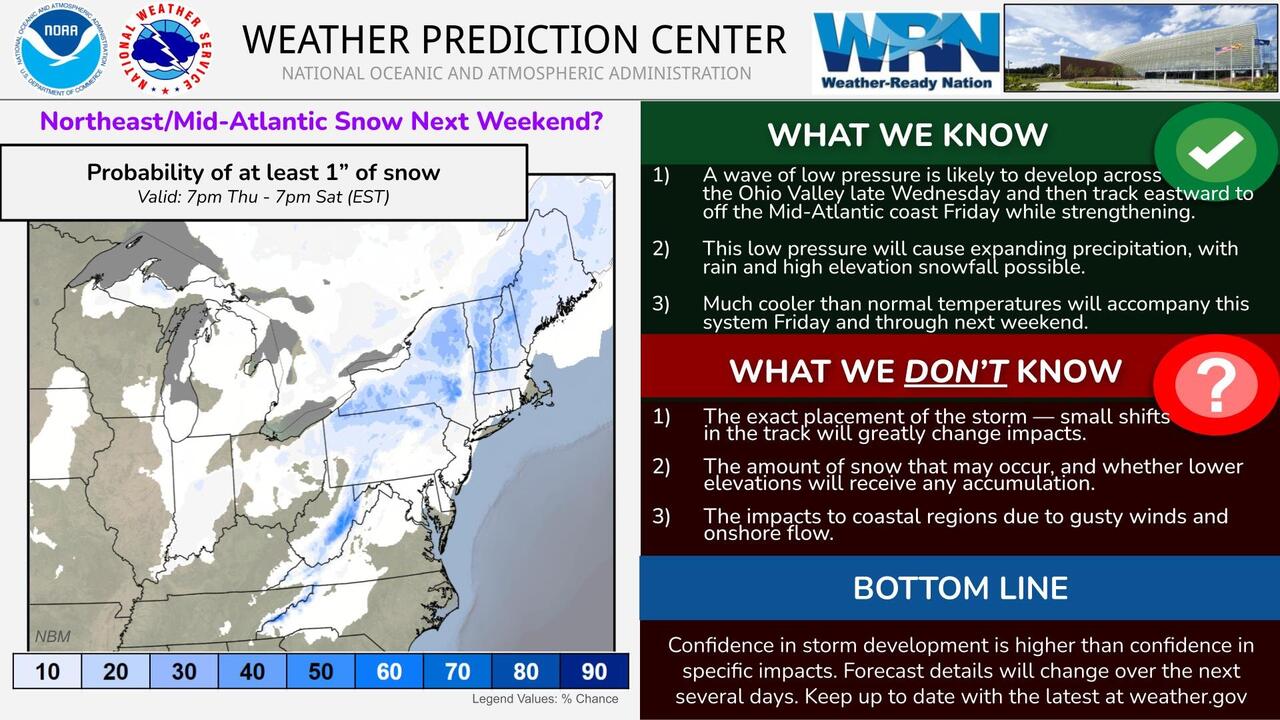
Cold Blast Puts Mid-Atlantic, Northeast On Watch For Season's First Snowstorm We've already outlined how crowded bearish positioning among hedge funds in US natural gas futures could leave the market vulnerable to a short squeeze next week, as forecasts point to a cold blast across the eastern half of the Lower 48. With cold air likely to be in place, meteorologists are watching to see whether moisture arrives at the same time, potentially bringing parts of the Mid-Atlantic and Northeast their first accumulating snowfall of the season
" Yes, there is a chance for a low-pressure system to bring mixed precipitation to the Mid-Atlantic and Northeast by next weekend. But, there remains a lot of uncertainty ," the National Weather Service's Weather Prediction Center wrote on X
FOX Weather says a low-pressure system is expected to develop over the Ohio Valley late next week and could move toward the Mid-Atlantic by Friday. It remains too early for certainty in the model guidance, but it appears moisture will mix with chilly Canadian air that could bring high temperatures in the 30s and 40s Fahrenheit across the Northeast, Great Lakes, and Ohio Valley, with overnight lows in the 20s
A building ridge of high pressure across the western US will favor milder temperatures and generally dry conditions across much of the Midwest next week! Track the latest temperature trends with the BAM Weather app! Sign up now: https://t.co/fXOKckicul pic.twitter.com/QO5fVbZ1X1
— BAM Weather (@bam_weather) November 8, 2026 " Amount of snowfall from a model = precipitation typed as snow hitting the ground. It may melt, compact, or be really fluffy. The actual measured accumulation is an entirely different ballgame ," meteorologist Ryan Maue wrote on X
Amount of snowfall from a model = precipitation typed as snow hitting the ground. It may melt, compact, or be really fluffy. The actual measured accumulation is an entirely different ballgame.
GFS -- when used properly (huge *) -- can provide useful guidance. pic.twitter.com/ofUczpwJht
Firewood Stacked? Meteorologist Warns "First Legit" Cold Blast Of Season To Hit Mid-Atlantic & Northeast
"Uncharted Territory": Arctic Vortex Could Break Earliest On Record
Could One Big Cold Snap Torch Hedge Funds' Record US NatGas Shorts
While the eastern US will experience colder-than-average temperatures and the threat of a snowstorm, the West will experience warmer and drier conditions
منبع: ZeroHedge — متن کامل از فید رسمی منبع، با ترجمهی ماشینی عنوان و خلاصه